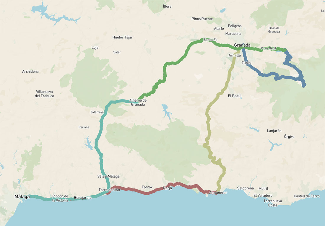
5 days cycling loop – Andalusia East
Five-day bikepacking route from Málaga to Granada and the Sierra Nevada, linking the Mediterranean coast with high mountain terrain
346km 6750hm
This five-day cycling route from Málaga explores eastern Andalusia, connecting the Mediterranean coast with the high mountains of the Sierra Nevada and the more remote inland landscapes of Granada province. The route moves from sea level along the Costa Tropical into the Baetic mountain system, where some of the highest peaks of the Iberian Peninsula rise, including Mulhacén (3482 m) and Veleta (3398 m), while also including several historically significant locations along the way.
The Sierra Nevada forms the central part of this cycling route, but the experience extends beyond the climb itself. The massif unfolds with strong contrasts – from the southern slopes of the Alpujarras, where white villages are set along the mountainsides, to the northern side, where the Hoya de Guadix, a wide inland valley, opens into broader inland landscapes.
Leaving Málaga, the route follows the coastline towards Almuñécar, with the Mediterranean remaining a constant presence. From here, it gradually turns inland, climbing through valleys and foothills towards Granada, a historic city set at the foot of the mountains.
From Granada, the cycle route continues into the high mountain environment of the Sierra Nevada, following one of the highest paved roads in Europe towards Veleta. This section defines the character of the journey, with long climbs, open alpine landscapes and a noticeable change in scale compared to the coastal and lowland terrain.
As the route descends from the mountains, it enters quieter inland areas, linking smaller villages such as Güéjar Sierra and continuing towards Alhama de Granada, a town dramatically positioned above a deep gorge and known for its historic setting and thermal waters.
From here, the final stage gradually returns towards Málaga, crossing inland valleys before descending back to the Mediterranean coast, completing a loop that links sea, mountains and remote interior landscapes into a continuous cycling experience.
This five-day route can be explored with different types of bikes available through bike rental in Malaga, depending on your travel style, luggage setup and preferred riding rhythm. For a route of this length, a comfortable trekking, gravel or e-bike setup works especially well, allowing you to adapt the journey to long days, changing terrain and multi-day cycling travel across Andalusia.
DAY 1: MÁLAGA – ALMUÑECÁR
78km 887hm
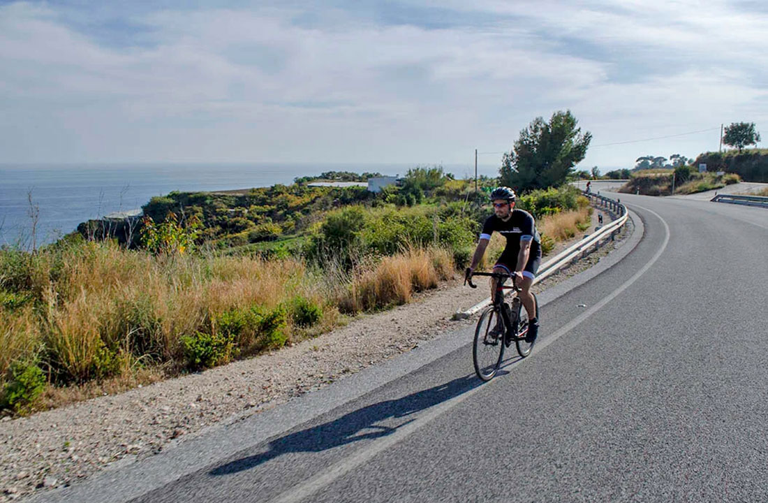
This trip starts with an easy ride along the shoreline of the Costa del Sol. Leaving Málaga, the route follows the N-340 road through the eastern districts of Pedregalejo and El Palo, continuing along the coastal towns that stretch towards Nerja. The first part of the ride can be combined between the seaside promenade and a smaller road running parallel to the main route.
The section to Nerja is mostly flat, passing through a sequence of coastal villages shaped by traditional Andalusian life, with beaches, small bars and a relaxed atmosphere. Nerja lies roughly halfway and offers a natural place to stop, known for its viewpoint over the sea and its position above the cliffs.
From this point, still on the N-340, the route leaves the more populated part of the coastline behind, following a winding coastal road above natural cliffs, offering a view of how this coastline once looked before the development of sandy beaches.
An undulating ride continues towards Almuñécar, one of the oldest settlements on the Iberian Peninsula, originally founded by the Phoenicians in the 9th century BC. Today, the town retains traces of its long history, including remains from Roman and Moorish periods, as well as a hilltop castle overlooking the bay.
Along the way, near Nerja, you will pass the Eagle Aqueduct, a 19th-century structure built to supply water to nearby sugar factories, notable for its decorative Mudejar-style details and prominent position above the valley. Further along in Almuñécar, you can also see the remains of a much older Roman aqueduct system, once part of the town’s water supply network, reflecting its importance during the Roman period.
DAY 2: ALMUÑECÁR – GRANADA
74km 1708hm

The second day is basically one long climb, but a really impressive one. The first 8km to the small village of Jete are flat, a good warm-up before the ascent begins. Then comes the climb to the pass called Collado de los Poyos (1276m).
First, a beautiful section about 24km long runs between rocky landscapes, later through pine forests, and then again more open, dry terrain. In the end, you reach around 1300 m of altitude, with continuous views around and back towards the sea. All this follows the quiet A-4050 road. Take enough water, as there are very few places to refill along the way. Closer to Granada, there is a better chance to stop for refreshments, especially near Otura.
The last section is more or less the entrance into Granada through the surrounding villages, and it is the busiest part of the route in terms of traffic, but still with impressive views towards the mountains. As you reach the city, set at the foot of the Sierra Nevada, with its often snow-capped peaks visible above, Granada reveals itself as one of the most remarkable places not only in Andalusia but in Spain as a whole, combining a dramatic natural setting with a rich and layered history shaped by different cultures over centuries.
Among its many historic sites, the Alhambra stands out as the city’s most iconic landmark. If you are planning to visit, tickets are typically booked in advance.
DAY 3: GRANADA – VELETA – GÜEJAR-SIERRA
73km 2961hm

The royal stage of the whole trip, especially in terms of elevation. Views from above 3000 metres are always impressive.
This is the longest climb of the route and one of the highest points that can be reached on an asphalt road in Europe (although there is always some discussion about the final section due to the effects of weather conditions). In general, temperatures here are significantly lower than on the coast, and snow can often remain on the higher sections even in summer.
There are several ways to reach the summit. The most direct option follows the main road A-395 from Granada towards the Sierra Nevada ski station (Pradollano). From there, the climb continues up to Hoya de la Mora, at around 2500 m, which marks the end of regular vehicle access. Beyond this point, the road is only accessible by bike and continues all the way to Veleta. The surface becomes more affected by altitude and weather conditions, but the landscape and the sense of scale make this section particularly memorable. There are alternative approaches to Veleta as well, via Monachil (GR-3202), offering a slightly different character.
All the way up to around 2500 m, there are several places to stop for food and water. Beyond that point, it is necessary to carry everything with you. The final section is more demanding, but the views – and the long descent that follows – fully justify the effort.
Güéjar Sierra– a small mountain village set at the northern edge of the Sierra Nevada, just above the Genil valley. Known for its quiet setting and proximity to high mountain routes, it offers a more local and less visited atmosphere compared to Granada, while still surrounded by dramatic scenery and access to the upper parts of the range.
DAY 4: GÜEJAR-SIERRA – ALHAMA DE GRANADA
72km 1021hm
After a climbing stage in the mountains, the route continues with a more relaxed, undulating ride over small hills towards Málaga province. Crossing Granada can be a bit busy, as expected, but soon the landscape opens up, with views towards La Maroma (2062 m), the highest peak in the province and a natural border between Granada and Málaga.
As the route turns left, the main climb of the day begins. While less demanding compared to the previous stage, it still offers a steady and enjoyable gradient. After Cacín, there is an option to continue directly towards Alhama de Granada or to follow a more scenic route via the Embalse de los Bermejales. From here, the road descends towards the lake, with open views across the surrounding landscape. Shortly after, the village of Arenas del Rey offers another opportunity to stop for refreshments before the final section.
Along the way, a more hidden option appears at a place known as El Ventorro, a quiet and remote spot that can serve as an alternative overnight stay for those less interested in reaching Alhama.
For those continuing, the final 5km lead into Alhama de Granada, a town known for its dramatic setting above a deep gorge, with a rich history and well-preserved architecture.
Alhama de Granada
A historic town dramatically set above a deep gorge, with its buildings perched along the edge of steep cliffs. Its name comes from the Arabic al-hamma, referring to the thermal baths that still exist below the town.
Alhama played an important role during the final stages of the Christian expansion in the region and retains a strong historical character, with narrow streets, traditional architecture and views over the surrounding valleys and mountains.
DAY 5: ALHAMA DE GRANADA – MÁLAGA
78km 564hm

The last day is a beautiful undulating route through the hills of the northern part of Málaga province, finishing with impressive descents into the centre of Málaga.
Leaving Alhama de Granada, the route follows the old road towards Ventas de Zafarraya, riding between open fields and along the foothills of the Sierra Tejeda. The terrain remains gently undulating, with short climbs and wide views throughout the day.
Approaching Ventas de Zafarraya, the landscape is defined by the striking pass of Boquete de Zafarraya. Here, or in the nearby village of Zafarraya, there are several options to stop for food before continuing.
The following descent runs between open hills and agricultural land, with views towards the plateau of the Depresión de Alfarnate, which the route enters shortly after. The route then continues in the direction of Colmenar. This section follows an undulating road at the base of the mountains, offering views across the hills and occasionally towards the coastline. In Colmenar, there are more options to pause before the final section along the Montes de Málaga Natural Park.
The last 32 km include around 20km of descent through the Montes de Málaga Natural Park. From the pass of Puerto del León, there is another opportunity to stop and take in the wide views over the Bay of Málaga. From here, only the final descent remains – a long and memorable finish back into the city.