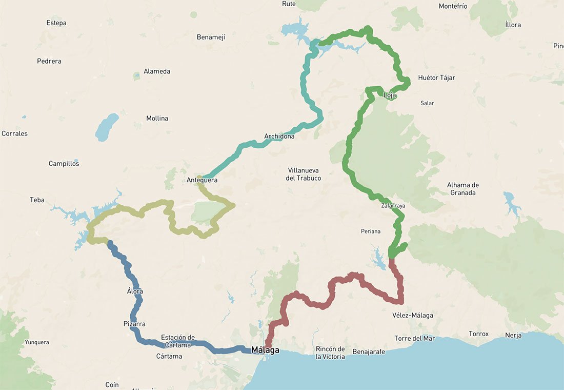
5 days cycling loop – Andalusia North
Five-day bikepacking route from Málaga into northern Andalusia, crossing the Penibética range and continuing through wide inland valleys
346km 6750hm
This multi-day cycling route from Málaga heads north into Andalusia, where the landscapes gradually open into a different terrain – quieter in form, but more expansive. As the route moves inland, the surrounding mountains give way to rolling hills, wide agricultural valleys and long stretches of olive groves that define much of cycling in this part of the region.
The transition becomes clear as the route crosses the mountain range separating the Costa del Sol from the interior of Spain. This system – part of the Cordillera Penibética – includes many of the mountain areas around Málaga, well known and widely used by cyclists, such as the Serranía de Ronda, Montes de Málaga and, further east, the Sierra Nevada, where the highest peaks of the Iberian Peninsula rise.
Beyond these mountains, the landscape changes noticeably. The terrain becomes more open and continuous, shaped by agriculture and long distances between villages. Roads connect small towns and rural areas, often following natural corridors across valleys and plateaus rather than climbing steep mountain passes – making it particularly well suited for long-distance cycling routes.
Historically, this part of Andalusia has always been more connected to inland Spain than to the coast, a contrast that remains visible along the route. Towns such as Antequera act as natural crossroads, while places like Álora or Alcaucín mark the transition between mountain terrain and the more open interior.
Riding north from Málaga means moving through landscapes shaped over centuries, where the rhythm of the route follows the land itself – creating a continuous and varied cycling experience across inland Andalusia.
DAY 1: MÁLAGA – ALCAUCÍN
72km 1953hm
To start the journey, you climb towards Fuente de la Reina / Puerto del León (900 m), following the old Granada road (A-7000) through the Montes de Málaga Natural Park. The ascent is steady and quiet, with open views over the Bay of Málaga accompanying the first part of the climb. There are a few places to stop along the way and at the top, where small restaurants offer a natural break before continuing inland.
After that, the cycling route turns towards Comares. You ride along the slopes below Santopitar (1020 m), with wide views across the Axarquía – a more agricultural landscape shaped by small farms and terraces, where avocado cultivation has become part of the scenery. During and after the descent, Comares, set high on a hill above the surrounding landscape, remains in view along this section. A short detour to Comares makes for an easy coffee stop if you prefer to pause along the way.
From there, a fast descent leads into the Benamargosa valley. The route then follows the river towards Trapiche, before continuing along the old A-7205 road towards Alcaucín, with open views towards La Maroma, the highest peak in the province.
Alcaucín marks the transition into the Sierra Tejeda area, a quieter mountain setting where the route begins to move away from the coastal influence and deeper into the interior.
Places of Interest Along the Route:
N.P. Montes de Málaga
A protected natural area just inland from Málaga, characterised by forested hills and quiet mountain roads. The climb towards Puerto del León is one of the classic cycling routes from Málaga.
Axarquía
An eastern region of Málaga known for its steep hills, fertile land and terraced landscapes. Shaped over centuries and influenced by Moorish rule, it remains one of the most characteristic rural areas for cycling in Andalusia.
Comares
A white village set high on a ridge, known for its panoramic views over the Axarquía. Historically of Moorish origin, it once held a strategic position overlooking the surrounding valleys. Its historic centre is particularly characterful, with much of its original structure and character still preserved.
Sierra Tejeda
A mountain range marking the transition between the coast and inland Andalusia. It is one of the key mountain formations in the region, forming a natural barrier between coastal and inland landscapes and shaping many of the classic cycling routes in this area.
La Maroma
The highest peak in the province Málaga (2062 m), forming part of the Sierra Tejeda range. It dominates the landscape around Alcaucín and is visible from several points along the route.
DAY 2: ALCAUCÍN – IZNAJAR
99km 2071hm
 The most demanding day of the loop, structured around a single major climb followed by a long descent and two shorter inland hills.
After descending towards Puente de Don Manuel, the route turns right and begins the ascent to Boquete de Zafarraya (900m), a well-known pass often featured in races such as the Vuelta a Andalucía and the Vuelta a España. The climb is steady and consistent over around 11 km, with La Maroma (2062m) rising to the right and the line of the pass gradually coming into view ahead.
The route then turns left towards Zafarraya, where a final section leads up to Cerro del Moro, the highest point of the day. From here, a long descent of nearly 30 km unfolds towards Loja, running between the hills of Sierra Gorda and Sierra de Alhama.
In Loja, there are options to stop before crossing the Genil river and continuing into the final section of the day. Two shorter climbs remain, followed by a quieter stretch of riding through olive groves, gradually approaching Iznájar and its reservoir, one of the largest in Andalusia.
At the top, a historic castle overlooks the surrounding valleys, reflecting the strategic importance of the village in earlier periods – once a frontier stronghold during the Reconquista, controlling the territory between Granada and Castile.
Places of Interest Along the Route:
Boquete de Zafarraya
A well-known mountain pass at 900m, forming a natural gateway between the coast and inland Andalusia, and the most important natural passage between the Axarquía and the province of Granada. Often featured in professional races, it offers a steady and consistent climb, with distinctive rock formations shaping the landscape along the pass. puerto natural que constituye el más importante paso entre la Axarquía y la provincia de Granada.
Loja
A historic town set along the Genil river, traditionally positioned as a key crossing point between eastern and western Andalusia. Its location makes it a natural stop along inland cycling routes.
Sierra de Alhama
A mountain range forming part of the transition between the Granada and Málaga provinces, where it connects with the Sierra Tejeda range, with exposed rock formations that define the landscape.Rio Genil
Castillo de Iznajar
A hilltop fortress overlooking the reservoir, originally established during the early Moorish period in the 8th century. It played an important role both during the Muslim conquest of the Iberian Peninsula and later, when control of the region shifted to Christian forces. Today, parts of the castle can be visited.
DAY 3: IZNAJAR – ANTEQUERA
50km 788hm
 Today’s shorter stage allows for a more relaxed start, with time to enjoy breakfast in Iznájar, overlooking the lakes. From here, the route continues through undulating terrain, with open views across the surrounding hills and agricultural landscapes.
The ride passes through quieter countryside before reaching the area around Salinas, where the road becomes slightly busier for a short section. Beyond this, the route returns to smaller roads, leading towards Archidona. Its central square, Plaza Ochavada, stands out as one of the most distinctive examples of Andalusian Baroque architecture, with its unusual octagonal form.
From Archidona, the route continues via small rural settlements such as Huertas before approaching Antequera. Historically a key inland centre, Antequera has long been considered one of the most important cities in Andalusia.
Among its main landmarks are the prehistoric dolmens of Menga and Viera, part of a UNESCO World Heritage Site and among the most significant megalithic structures in Europe. The city itself is also known for its concentration of churches and its well-preserved historic centre, making it a natural place to spend more time at the end of the day – as well as for its excellent gastronomy.
Things of Interest Along the Route:
Archidona
A historic inland town known for its distinctive octagonal main square, Plaza Ochavada, one of the most characteristic examples of Andalusian Baroque urban design.
Antequera
One of the most historically important inland cities in Andalusia, long considered a strategic crossroads of the region. Its historic centre is known for a high concentration of churches and well-preserved architecture, with numerous historic sites, museums and public spaces to explore. Above the city, the Alcazaba de Antequera, a historic hilltop fortress, overlooks the surrounding landscape.
Peña de los Enamorados
A distinctive rock formation visible from several points on the approach to Antequera, often said to resemble the profile of a reclining human face. According to local legend, it takes its name from two lovers who, fleeing their pursuers, leapt from the rock – a story that has become part of the identity of the landscape.
Porra Antequerrana
A traditional cold tomato-based dish, similar to gazpacho but thicker and more intense in flavour. It is one of the most typical local specialities and closely associated with the gastronomy of Antequera.
Dolmens of Antequera
A group of prehistoric megalithic monuments dating back to the Neolithic period, including the Dolmen of Menga, one of the largest in Europe. Today, the site is recognised as a UNESCO World Heritage Site and remains one of the most significant archaeological landmarks in Andalusia.
DAY 4: ANTEQUERA – EL CHORRO
70km 1429hm
 Another long day, with significant elevation and a more demanding profile after the previous stage.
Leaving Antequera, the route heads towards the limestone massif of El Torcal, one of the most distinctive natural areas in the region. This karst landscape, formed during the Tertiary period and shaped by centuries of erosion, creates a unique terrain of layered rock formations. From Antequera, the approach is gradual, with around 12 km leading to the junction for El Torcal, followed by a final 3 km climb to the top. A small restaurant and the surrounding viewpoints offer a natural place to pause before continuing.
Returning to the main road, the route continues towards Villanueva de la Concepción and later La Joya, following undulating roads along the edge of the El Torcal massif. After La Joya, a short climb leads over Puerto de la Joya (899 m), before descending towards Valle de Abdalajís.
Before reaching the village, a small turn leads away from the main road towards the Guadalhorce–Guadalteba reservoir system. This quieter section follows the lakes through a more remote landscape, with very little traffic and a strong sense of isolation compared to earlier parts of the route.
The final stretch continues along the reservoirs before descending towards El Chorro, known for its hydroelectric station and the dramatic gorge – Desfiladero de los Gaitanes – that cuts through the landscape. This is also the location of the Caminito del Rey, one of the most distinctive walking routes in the area. Staying overnight here allows time to experience the gorge and its surroundings more fully.
Places of Interest Along the Route:
El Torcal de Antequera
A unique karst landscape formed from limestone rock, shaped over millions of years into layered and sculptural formations. It is one of the most distinctive geological sites in Andalusia.
Guadalhorce–Guadalteba reservoir
A system of interconnected reservoirs surrounded by hills and forest, forming one of the most significant inland water landscapes in Málaga province.
El Chorro
A small settlement known for its dramatic natural setting, located beside the narrow gorge of the Garganta del Chorro, where steep limestone walls define the landscape. The area also serves as a starting point for several short cycling routes described on this site.
Caminito del Rey
The well-known Caminito del Rey is also located here – a narrow walkway built along the steep walls of the gorge, originally constructed for maintenance of the hydroelectric system. Today, it is one of the most distinctive walking routes in the region and typically takes several hours to complete. Tickets are usually booked well in advance for those planning to visit.
DAY 5: EL CHORRO – MÁLAGA
54km 508hm

After breakfast with views over the gorge, the final stage leads back towards Málaga. Although returning towards the coast, the cycling route still passes through a number of characteristic inland landscapes.
Riding in the direction of Álora, the terrain opens into the Guadalhorce valley, one of the most fertile areas in the region, known for its olive groves, citrus plantations and long agricultural tradition. In recent years, local wine production has also become more prominent.
From here, the route gradually returns towards more urbanised areas as it approaches the outskirts of Málaga. Along the way, there are several opportunities to stop, particularly in and around Álora, where local products such as olives and traditional dishes reflect the character of the region.
Things of Interest Along the Route:
Álora
Álora is one of the older settlements in the area, with a hilltop castle of Moorish origin overlooking the valley. A short climb into the village offers wider views across the surrounding landscape. It is a typical Andalusian white village, with narrow streets and traditional architecture.
Álora Castle
Castillo de Álora – hilltop fortress overlooking the Guadalhorce valley, with origins dating back to the Moorish period. From its elevated position, it offers wide views over the surrounding landscape and extensive olive groves. The castle is open to visitors.
Restaurante Los Caballos
A local roadside restaurant set on the site of a historic venta, popular with farmers, cyclists and motorbike riders. Located along several well-known routes through the area, it is known for its traditional regional cuisine and simple, authentic atmosphere. A fitting place to mark the approach to the final section of the route, as Málaga comes closer.