Cycling route from Málaga to El Torcal
2-day bikepacking route to Villanueva de la Concepción with an extention to El Torcal de Antequera
82km 1600hm
This two-day cycling route leads into the inland landscapes of northern Málaga province, with El Torcal de Antequera as its main natural highlight. The route is centred around the park’s unusual limestone formations – one of the most distinctive geological areas in Andalucía – and naturally invites time off the bike for scenic walks and exploration on foot. It is especially well suited to cyclists who enjoy discovering unusual places on foot just as much as the riding itself.
Heading north from Málaga, the route passes through typical inland landscapes of mountains and valleys and olive groves, gradually climbing toward the limestone ridge of El Torcal. We suggest Villanueva de la Concepción as an overnight stop: it is the closest village to the natural park on the Málaga side and a classic pueblo blanco in its own right, offering a calm rural atmosphere and convenient access to the surrounding natural area.
The bike route is suitable for trekking, gravel and road bikes. The only section that may be less comfortable for road bikes is on the return leg toward Almogía, where you’ll encounter a short stretch of slightly damaged road.
Route description
The ride begins in the city and heads north-west, following one of the most direct routes out of Málaga toward the inland districts. After passing through the urban area of Puerto de la Torre, traffic gradually thins out and the riding becomes calmer and more enjoyable.

On the map, the route forms a clear loop around Embalse de Casasola. This reservoir plays an important role in the region, serving both as a drinking water source for Málaga and as flood protection during periods of heavy rain, while also blending beautifully into the surrounding landscape. On the first day, you approach the reservoir from its eastern side. On the return toward Málaga, the route follows the opposite shore via Almogía, offering a different perspective without repeating the same road.
For much of this section, the Campanillas River accompanies the route, shaping a softer inland environment where water, vegetation and farmland come together. This riverside landscape has supported human settlement since ancient times. Today, small farms still line the road, and it’s not unusual to encounter free-roaming farm animals – a reminder that this is a living rural landscape, best ridden with attention and an easy pace.
After leaving the reservoir behind, the route follows the river corridor and passes alongside a narrow canyon shaped by river and reservoir waters, locally known as Charco del Infierno (Hell’s Pool), with rugged stone walls and dark pools carved into the rock.
As the route continues to climb, the characteristic outline of Sierra del Torcal gradually comes into view, with the small town of Villanueva de la Concepción appearing below – a clear visual marker that you are approaching the heart of this inland landscape.

On the return day, the route passes through another mountain village – Almogía. As you approach the town, you can choose to continue directly downhill or take a short detour into the village itself. Almogía is compact and steep, with narrow streets that lead naturally to the Plaza de la Constitución, the social heart of the town. Here, local cafés fill with everyday life – neighbours gathering over coffee, exchanging news and setting the rhythm of the morning.

From Almogía, the final descent back toward Málaga begins. The road follows part of the historic Mozarabic Way of St. James, the inland route once used by pilgrims travelling north. This last section is a long, flowing descent that gradually brings you back into the city – a smooth and satisfying return after a quiet journey through inland valleys, villages and mountain landscapes.
Villanueva de la Concepción
Villanueva de la Concepción is a quiet white village with a long and layered past. Inhabited since prehistoric times, it has carried traces of different historical periods and has endured thanks to its strategic location along the camino real – the old royal road that once connected Málaga with Madrid. Today, the village retains a warm, authentic atmosphere, closely tied to the surrounding mountain landscape. Daily life here follows a calm rural rhythm, shaped by agriculture and the steady presence of the sierras.
Its position at the very gateway to El Torcal Natural Park makes Villanueva de la Concepción an ideal overnight stop: close enough to reach the limestone formations early in the morning, yet peaceful and inviting in the soft light of the afternoon. Small cafés and local restaurants, narrow streets lined with whitewashed houses, and open views toward the dramatic rock formations above complete the experience.

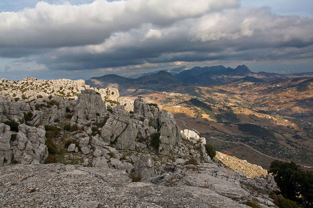
El Torcal
El Torcal Natural Park is the highlight of the loop – a surreal labyrinth of rock towers and rounded boulders, and one of the most unique geological landscapes in Spain. Several walking trails start from the visitor area and can easily fill a couple of hours. Although the park itself is relatively compact, its dramatic scenery often invites visitors to stay longer and explore at a slower pace. You can also simply visit the main viewpoint and climb to the panoramic ridge – a wide platform of ancient, weather-smoothed limestone slabs. From here, you can look both into the natural stone amphitheatre formed by the surrounding rock formations and outward across the distant mountains and plains. There is a small café at the top, where you can try porra antequerana, a local cold tomato soup and regional specialty, and enjoy the unusual, almost otherworldly setting.
To reach El Torcal by bike, follow the A-7075 — the same road you used to arrive in Villanueva de la Concepción.
Optional route extention – El Chorro
For travellers who wish to expand the adventure, this loop can naturally be extended into a three- or four-day itinerary by adding another mountain highlight: El Chorro and the dramatic gorge of Caminito del Rey – a rewarding continuation for those who want to explore even more natural landmarks in the Málaga region. We are currently working on a more detailed route and will publish it soon.

This route was previously published as a road bike route on our old Escapada website. We updated the content to reflect our new Travel & Adventure concept while keeping the same region and key highlights.
Images and text by the Escapada Cycling team and pintarroja art