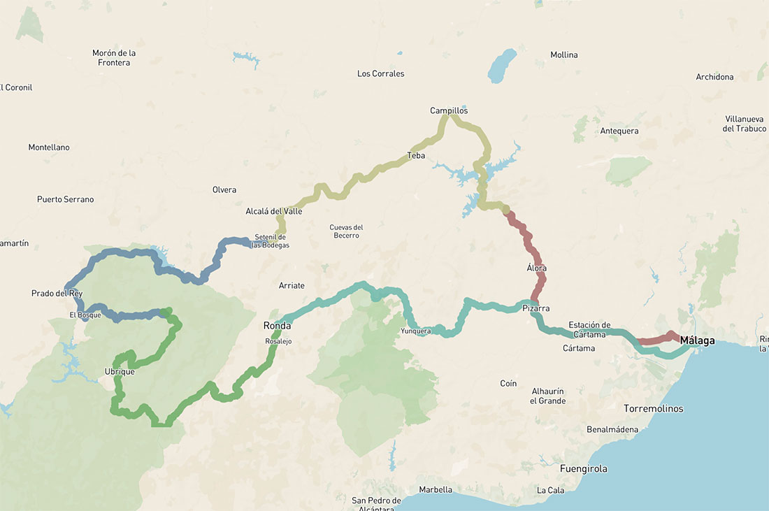
5 days cycling loop – Andalusia West
Five-day cycling loop from Málaga through western Andalusia, linking white villages, mountain ranges and scenic inland roads
390km 6930hm
This multy-day cycling route from Málaga explores the western part of Andalusia, moving through a sequence of landscapes that gradually shift from coastal terrain to more remote inland mountains and limestone formations shaped by the Baetic Cordillera, as well as historic white villages along the way.
Leaving Málaga, the route heads inland through the valley of the Guadalhorce river towards El Chorro, where steep limestone walls and the narrow gorge of the Garganta del Chorro create one of the most dramatic natural settings in the region. From here, the terrain opens into quieter rural areas, leading towards Setenil de las Bodegas, known for its distinctive architecture built directly into the rock.
Further west, the bike route enters the Sierra de Grazalema, one of the highest and wettest areas in southern Spain and a protected natural park characterised by greener landscapes, higher elevation and a more remote atmosphere. The terrain here becomes more mountainous, with limestone ridges, forested slopes and narrow valleys, while the village of Grazalema sits within this landscape as one of the most characteristic settlements of the area.
The cycling route then continues towards Ronda, located on a plateau divided by the deep El Tajo gorge, carved by the Guadalevín river. This dramatic geological feature defines the structure of the town and its position within the surrounding mountains of the Serranía de Ronda.
From here, the final stage returns towards Málaga, descending from the inland ranges back towards the Mediterranean coast, completing a loop that connects coastal, mountainous and inland Andalusian landscapes into a continuous and varied cycling experience.
DAY 1: MÁLAGA – EL CHORRO
55km 748hm
Another day in the mountains, with slightly less elevation but fully immersed in the landscapes of the Sierra de Grazalema. The first part of the route is easier, following a combination of flat and descending sections towards Ubrique, passing through a varied landscape of fields, meadows, rocky peaks and scattered pine forests.
After Ubrique, the terrain changes, with a longer climb winding through forested slopes as the route approaches Cortes de la Frontera, a quiet village and a natural place to pause before continuing deeper into the mountains.
From here, the route continues towards Jimera de Líbar, following the valley before beginning the climb towards Atajate, one of the smallest villages in the province.
For those interested in speleology, an optional detour leads towards Cueva de la Pileta, located around 12 km away near Benaoján. The cave contains prehistoric cave paintings dating back more than 20,000 years and is considered one of the most important sites of its kind in Spain.
For those going via Atajate, the route continues over the final mountain pass of the day, Puerto de las Encinas Borrachas (1011 m). From the top, a long descent leads directly towards Ronda, with a scenic approach to the city.
The final approach to Ronda passes through the historic Puerta de Almocábar, one of the main entrances to the old town, built in the 13th century during the Moorish period.
Ronda
One of the most historic towns in inland Andalusia, set on a plateau divided by the deep El Tajo gorge, carved by the Guadalevín river. Its position made it a strategic settlement from early periods, later developing under Moorish rule before becoming part of the Christian territories.
The town offers a wide range of historic sites, museums and places to explore, reflecting its long and layered history. Three bridges span the gorge — often associated with Roman, Moorish and later Christian periods — illustrating the different stages of the city’s development. From ancient remains to more recent architecture, Ronda presents a continuous historical timeline shaped by successive cultures.
DAY 2: EL CHORRO – SETENIL DE LAS BODEGAS
75km 1323hm
Today’s ride covers a medium distance, with a varied profile that combines flatter sections with longer climbs. The route begins with an uphill stretch towards the Guadalhorce–Guadalteba reservoir system, one of the main sources of drinking water for much of Málaga province.
After this initial climb, the cycle route continues towards Campillos, where there is an opportunity to pause before heading further inland. From here, the route passes near Teba, where an optional short climb leads to the remains of Teba Castle, offering wide views over the surrounding countryside.
The route then continues towards Cañete la Real, where a longer climb of around 10km leads to the highest point of the day. This is a quiet village with the remains of another castle, set in a more elevated and open landscape.
From here, the terrain becomes more undulating again, following smaller roads between agricultural fields and the surrounding hills of the local sierras. The day finishes in Setenil de las Bodegas – one of the most distinctive villages in Andalusia, where houses are built directly into and beneath large rock overhangs. The streets follow the natural shape of the rock, creating a unique architectural landscape formed by the interaction between geology and settlement.
DAY 3: SETENIL DE LAS BODEGAS – GRAZALEMA
76km 1868hm
The queen stage of the loop, this is the day where the terrain becomes more demanding and the surrounding landscape fully reflects it. Entering the heart of the Serranía de Ronda, the route is defined by pine forests, limestone formations and a continuous sequence of climbs and descents.
The day begins with an undulating section towards Zahara de la Sierra. Along the way, there is an optional detour to Acinipo, the remains of an ancient Roman settlement located slightly off the route between Setenil and Montecorto. The site includes a well-preserved Roman theatre and offers wide views over the surrounding landscape.
As the route approaches Zahara de la Sierra, the village appears above the reservoir, with its castle positioned on the hilltop. Originally a Moorish settlement, it later became a key defensive point and marked the beginning of the final phase of the Reconquista leading towards the Kingdom of Granada. The road follows the edge of the dam, with open views across the water and the surrounding mountains.
From here, a flatter section leads towards El Bosque, running along the foothills of the Sierra de Grazalema. In El Bosque, there are several places to stop before the main climb of the day.
The ascent to Puerto del Boyar (1107 m) is steady and well-paced, following a road that gradually gains elevation over around 15 km. With an average gradient of approximately 4.5%, it remains a manageable climb, passing below the peak of El Torreón (1648 m), the highest point in the Sierra de Grazalema.
At the pass, open views and a small picnic area offer a place to pause before the final descent. The last kilometres lead downhill into Grazalema, a white village with a long history, known for its traditional textile production, particularly wool blankets that were once traded across the region. Its compact historic centre, narrow streets and small squares reflect its mountain setting and strong local identity.
DAY 4: GRAZALEMA – RONDA
83km 1670hm

Another day in the mountains, with slightly less elevation but fully immersed in the landscapes of the Sierra de Grazalema. The first part of the route is easier, following a combination of flat and descending sections towards Ubrique, passing through a varied landscape of fields, meadows, rocky peaks and scattered pine forests.
After Ubrique, the terrain changes, with a longer climb winding through forested slopes as the route approaches Cortes de la Frontera, a quiet village and a natural place to pause before continuing deeper into the mountains.
From here, the route continues towards Jimera de Líbar, following the valley before beginning the climb towards Atajate, one of the smallest villages in the province.
For those interested in speleology, an optional detour leads towards Cueva de la Pileta, located around 12 km away near Benaoján. The cave contains prehistoric cave paintings dating back more than 20,000 years and is considered one of the most important sites of its kind in Spain.
For those going via Atajate, the route continues over the final mountain pass of the day, Puerto de las Encinas Borrachas (1011 m). From the top, a long descent leads directly towards Ronda, with a scenic approach to the city.
The final approach to Ronda passes through the historic Puerta de Almocábar, one of the main entrances to the old town, built in the 13th century during the Moorish period.
Ronda
One of the most historic towns in inland Andalusia, set on a plateau divided by the deep El Tajo gorge, carved by the Guadalevín river. Its position made it a strategic settlement from early periods, later developing under Moorish rule before becoming part of the Christian territories.
The town offers a wide range of historic sites, museums and places to explore, reflecting its long and layered history. Three bridges span the gorge – often associated with Roman, Moorish and later Christian periods – illustrating the different stages of the city’s development. From ancient remains to more recent architecture, Ronda presents a continuous historical timeline shaped by successive cultures.
DAY 5: RONDA – MÁLAGA
101km 1320hm

The final day of the loop is mostly descending, as Ronda sits at around 700m above sea level while Málaga lies at the coast. However, the route still crosses the landscapes of the Sierra de las Nieves, with two final climbs before the long descent towards the valley. Both are relatively short, with steady gradients.
Leaving Ronda, the route follows the old A-366 road, passing near the Conrad winery, before reaching the first pass, Puerto del Viento (1075m), after around 7km. From here, a long descent leads towards El Burgo, with a short undulating section along the way and wide views across the surrounding mountains.
Approaching El Burgo, there is an option to stop at the Guarda Forestal viewpoint, offering panoramic views over the surrounding ranges. In the village itself, it is possible to pause and refuel before the final climb of the day.
From El Burgo, the route continues towards Yunquera, climbing steadily to Puerto de las Abejas (822m). The ascent is around 6km on a wider road, with a consistent and manageable gradient. In Yunquera, there are places to stop before beginning the long descent towards Málaga.
The final section follows a gradual descent of around 30km through Alozaina, Casarabonela and Pizarra, as the landscape transitions from mountain terrain back into the valley. Near Casarabonela, there is also the option to visit a botanical garden specialising in cactus.
By the time you reach Pizarra, most of the route is complete, with the remaining distance leading through the outer districts of Málaga. For those who prefer to avoid this section, the local Cercanías C2 train offers a convenient alternative back to the city. Continuing by bike, the route passes through Aljaima, Estación de Cártama and Campanillas before following the A-7054 road into the centre of Málaga, completing the route.
Returning to Málaga, the journey comes full circle, connecting mountains, villages and valleys into one continuous experience.