Cycling route from Málaga to El Chorro
More day bikepacking route from Malaga to El Chorro, with optiona bike route extentions and several overnight option
130km 969hm
This multi-day cycling route leads through the inland mountain and nature areas of Málaga province, passing geological formations, natural landmarks and the historical heritage of the region. The landscapes shift gradually along the route – from low rural hills to more enclosed rocky terrain and then to quiet inland water areas.
You can choose to spend the night in Álora, El Chorro, Ardales or Valle de Abdalajís. All of these towns work naturally as overnight bases for multi-day cycling routes. In this guide, we describe a version with two nights in El Chorro and include several optional route variations for the second day, so you can adapt the journey to your preferences.

For travellers who prefer different overnight combinations, there are several ways to adjust the route. One possibility is to stay the first night in El Chorro and the second in Ardales, which lies naturally along the route after the lakes. Another option is Valle de Abdalajís, with the alternative to return to Málaga through a more direct inland line. Álora can also serve as an additional overnight stop – either on the way out or on the way back – as a lively white town overlooking the Guadalhorce Valley, with cafés, small squares and a hilltop Moorish fortress. Each place offers a slightly different setting, allowing you to choose the overnight location that best matches your plan and rhythm.
We also include three additional route extensions that can be done as day rides from El Chorro and can be optionally added to the itinerary if you wish to explore the area further.
There is also the possibility to include a visit to Caminito del Rey as part of the journey. The area around the walkway is one of the most distinctive geological sections of this region, with narrow rock walls and clear views over the reservoirs. Access is regulated and requires booking in advance, so it is helpful to secure a time slot that matches your stay in El Chorro.
The route is suitable for relaxed cycling travel and light bikepacking, with several options to adjust daily distance and rhythm. This bike journey can be enjoyed on almost any type of bike, depending on your abilities, preferences, and the length of the daily stages – including modern e-bikes with powerful batteries.
Route Description
The route begins by following the wide Guadalhorce Valley – one of the defining inland landscapes of Málaga. This opening section leads through farmland and small agricultural areas lying along the riverbanks, as well as gentle rolling hills framed by the distant silhouettes of the surrounding sierras.

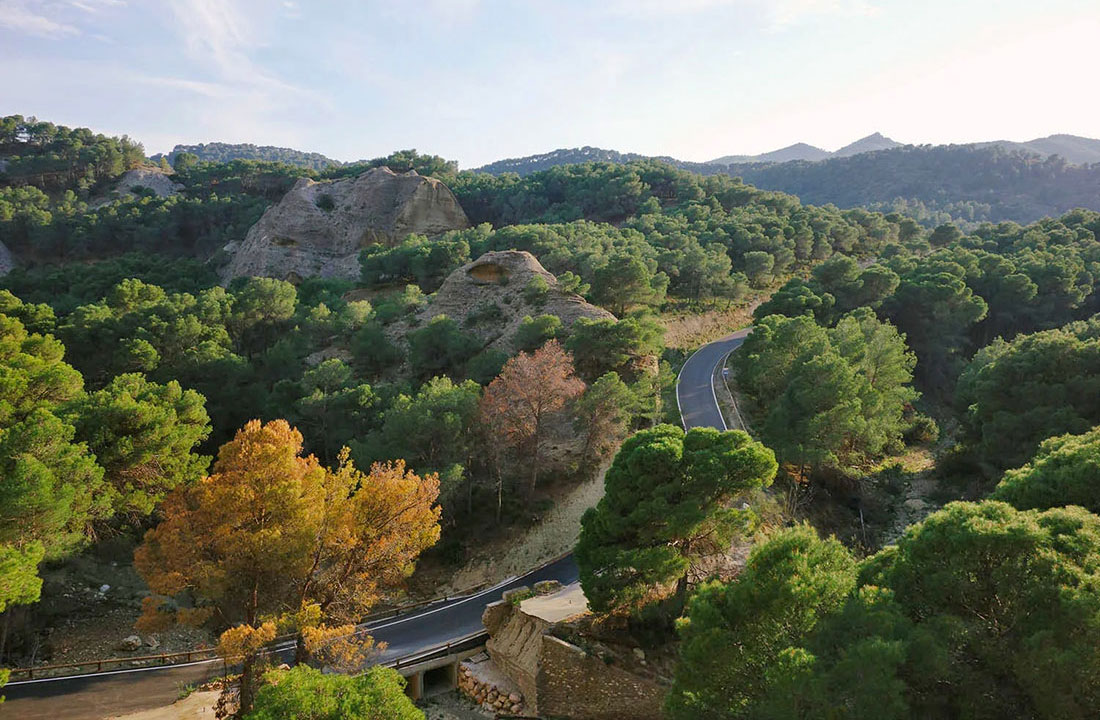
As you continue, the road gradually narrows and the landscape becomes more dramatic. The first historical town along the way is Álora, situated above the valley with its whitewashed houses and hilltop Moorish castle. From here, the approach to El Chorro unfolds in a series of beautiful transitions: rocky slopes, steep cliffs and the unmistakable profile of Sierra de Huma coming into view. The road winds between stone walls and pine forests before suddenly opening to the grand scenery of the Desfiladero de los Gaitanes (Garganta de los Gaitanes / Gaitanes Gorge) – one of the most iconic natural landmarks in Málaga.
After passing the Desfiladero de los Gaitanes, the route reaches the turquoise waters of the Ardales lakes, and the landscape changes again. Nearby lies the village of Ardales, one of the traditional pueblos blancos typical of this region. The area is surrounded by forested slopes and quiet bays, with a more open and calm character compared to the rocky sections earlier on the route.
On the way back, the route passes through Álora again, allowing time to visit the town if it was skipped on the outward section, and then follows the Guadalhorce Valley before arriving in Málaga.
Additional Routes from El Chorro
From El Chorro, several short bike route extensions can be explored, each showing different aspects of the surrounding landscape. These options work well as short day rides and can be used to complement or diversify overnight stays in the area.

Route to the Ruins of Bobastro (red line)
14km 360hm
This short extension offers a chance to visit a unique site set within the limestone landscapes above El Chorro: the Ruins of Bobastro. The area contains one of the most unusual historical locations in the region – the remains of a 9th–10th century Mozarabic settlement carved directly into the rock. Visitors will find the foundations of a church, traces of former houses and wide views across the valley.

Peñarrubia Loop — Across the Lakes (yellow line)
41km 781hm
This bike route leads you around the turquoise reservoirs toward Peñarrubia, a small settlement on the opposite side of the lakes, with several prehistoric archaeological sites scattered throughout the surrounding hills. The road alternates between pine forests, stretches of open water and small coves, with occasional viewpoints where the landscape opens over the lake system.

Scenic Loop from El Chorro to Valle de Abdalajís (green line)
38km 855hm
This loop climbs gradually toward Valle de Abdalajís, crossing a landscape shaped by limestone walls, open farmland, and long views toward the Sierra de Huma. Valle de Abdalajís is a traditional inland village with a slower rhythm and wide, open views toward the surrounding sierras, one of the characteristic villages set high in the mountains.
Overnight Options

El Chorro
El Chorro is the natural centre of this journey, with cliffs, pine forests and the deep Gaitanes Gorge shaping the landscape. Staying here provides direct access to several short riding loops, viewpoints and forest roads, as well as the entrance to the Caminito del Rey. The combination of limestone formations, quiet valleys and easy connections to different day rides makes El Chorro one of the most practical overnight bases for cycling travel and light bikepacking in inland Málaga.
Ardales
Ardales lies just beyond the turquoise lakes, a peaceful white village with narrow streets, local cafés and a relaxed inland atmosphere.
Valle de Abdalajís
Set between open farmland and the rising limestone walls of the surrounding sierras, Valle de Abdalajís offers a quieter and more rural perspective, closely tied to the landscape.

Álora
Álora adds a cultural and historical layer to the journey – a pleasant white town overlooking the Guadalhorce Valley, shaped by its Moorish fortress and narrow historic streets. Making a stop here works well either on the outward or return section. The town is small, but it can also be included as an additional day for travellers who wish to slow down and enjoy the more traditional side of inland Andalucía. With small squares, cafés, viewpoints, and long views over olive groves, Álora offers a mix of rural life and cultural heritage.
Álora is closely linked to olive oil production, with olive groves surrounding the town in every direction. A local olive variety, La Aloreña, is traditionally grown in this area and takes its name from the town.
Cultural Highlighs

Caminito del Rey
One of the most distinctive geological and historical areas of inland Málaga, with narrow limestone walls and views over the reservoirs. Access is regulated and requires advance booking.
Ruins of Bobastro
A unique Mozarabic site carved into the limestone above El Chorro. The remains of a 9th–10th century settlement and its rock-cut church offer a rare combination of history and landscape.
As you can tell from the number of photos, we really like this area and visit it often :) We hope you also have a good time here!


This route was previously published as a road bike route on our old Escapada website. We updated the content to reflect our new Travel & Adventure concept while keeping the same region and key highlights.
Images and text by the Escapada Cycling team and pintarroja art